
Coastal section: Birling Gap
Sussex RIGS number: TV59/09
Forms part of the Seaford to Beachy Head SSSI designated for its geological and biodiversity value (Site Code 1000182)
The cliffs and foreshore of the LGS site are located within Unit 2 of the SSSI.
Forms part of the Beachy Head to Seaford Head Geological Conservation Review (GCR) Site
Block: Coastal Geomorphology of England (Site Code 1850)
Designated as Birling Gap Geological Conservation Review (GCR) Site
Block: Quaternary of South-East England (Site Code 790)
Birling Gap is within the South Downs National Park
Grid Reference: TV553960
Owner:
National Trust
Site access:
Birling Gap is sign-posted from the A259 at East Dean, between Seaford and Eastbourne and is about 2 km south of the A259 via Birling Gap Road. There is a pay and display car park at Birling Gap.
Access to the beach is by temporary steps which can be washed away by storms or damaged by cliff falls. Great care should be taken regarding potential cliff falls and tide conditions. The site is suitable for large groups.
Summary Description:
21/07 and 09/08/2011
(from East Sussex RIGS Survey 2011)
Interest Feature(s)
Bedrock:
about 500 m of undefended chalk cliffs from 15 to 30 m in height and wavecut platform exposing Seaford Chalk.
Stratigraphy: Seaford Chalk Formation, White Chalk Subgroup, Upper Cretaceous (Coniacian-Santonian) in age.
Sedimentology: Seaford Chalk with relatively uniform texture and closely spaced tabular and nodular flint bands.
Structural geology: horizontal bedding at centre of Birling Gap syncline.
Superficial deposits
The cliffs cut across a dry valley, exposing one of the best cross-sections of a dry valley to be seen anywhere in Britain. A complex series of Pleistocene valley fill deposits in the bottom of the dry valley overlie deeply weathered chalk. A thin layer of loessic material underlies upper valley slopes.
Stratigraphy: Pleistocene, probably Devensian or Loch Lomond Stadial in age, and Holocene.
Sedimentology: 5 m of flinty gravels, sands and flinty coombe rock with fine chalky wash at the western edge of the valley. Thin loessic deposits on upper slopes.
Sedimentary structures: loading structures occur at the base of the thin loessic layer. There are several features in the section that look like channels, as they have at least one near-vertical margin, especially on the west side. This may imply a series of migrating channels which gradually infilled the valley. The lower valley fill is marked by large scale contortions probably caused by thawing of deep-seated permafrost. The valley fill is underlain by weathered chalk bedrock forming a chalk rubble including distorted and broken flint layers. Distortion of flint bands probably associated with active layer processes and permafrost melting.
Geomorphology
Birling Gap is a classic chalk dry valley showing deep in situ chalk weathering beneath the valley bottom.
Site map - Aerial photography 2005 - Survey visits 21/07 and 09/08/2011
RIGS Designation Criteria:
Scientific Details and Site Description
Stratigraphy: Birling Gap is a valley cut into Upper Cretaceous chalk cliffs; the Seaford Chalk and part of the Cuckmere Beds.
Sedimentology and geomorphology: The intact chalk consists of pure white chalks with prominent flint seams and several marl seams. The sediments which are the result of geomorphological processes such as valley cutting, and quaternary periglacial processes are 5m of flinty solifluction gravels and flinty Coombe Rock which underlies the valley floor at Birling Gap. The base of the flinty Coombe Rock is disturbed by large-scale contortions which penetrate too far below the surface to be active-layer phenomena. They were most probably developed at the end of the Devensian when deep-seated permafrost was thawing.
This flinty Coombe Rock is underlain by 5m or more of broken bedrock chalk forming a chalk rubble or pseudo Coombe Rock. Large blocky lumps of chalk are embedded in a pasty groundmass, along with broken flints. This extends down to beach level and passes laterally into sound, unweathered chalk under the valley sides. The unweathered Chalk contains numerous horizontal lines of flints which if followed horizontally, retain their position initially, becoming wavy and finally completely broken up, proving that the rubble is bedrock broken up in situ.
On the western side of the Gap, the flinty Coombe Rock passes laterally into fine chalky wash which is banked against the bedrock at a peculiar vertical junction like a miniature cliff. The origin of this is uncertain but could be the side of an old stream channel.
Very fine involutions underlie the upper slopes of the valley on each side and are associated with a thin layer of brickearth. These may have formed at the end of the Devensian during a period of relative slope stability.
Educational value: The sea cliffs at Birling Gap provide one of the best cross-sections of a dry valley to be seen anywhere in Britain. A complex series of solifluction deposits on the floor of the valley overlie deeply weathered chalk. The large scale contortions may have originated when permafrost melted at the end of the Devensian. A well-developed layer of involutions underlies the valley sides, merging into the solifluction deposits on the valley floor. Birling Gap is an extremely important site for periglacial and chalk geomorphology. While not all the processes are fully understood and explained the site is very important for future research. Because of the marine erosion of approximately 1m per year the cliff is kept relatively free of talus and the deposits are not obscured.
SSSI Designation Criteria (citation):
Extracts:
Seaford to Beachy Head is an outstanding site of national importance for its biological and geological features. The diverse range of habitats includes herb-rich chalk grassland, chalk heath (a unique, rare habitat on chalk soils), maritime grassland, foreshore and chalk cliffs, river meanders, and Greensand reef. Together, these habitats support a number of nationally rare, nationally scarce and nationally significant plants, invertebrates and birds.
The cliffs and chalk platform beneath are identified in the Geological Conservation Review as outstanding for their geological and geomorphological interest.
The site lies at the eastern end of the South Downs which terminate in the chalk cliffs of the Seven Sisters. The majority of the site, therefore, lies on chalk but the River Cuckmere breaches the cliffs to form a broad alluvial valley. There is also a distinct coastal zone which includes all of the geological interest.
Geology
The site is important for earth science interests, particularly for its chalk stratigraphy, periglacial geomorphology and the study of chalk landscape evolution.
Birling Gap is a key site for periglacial geomorphology and the study of chalk landscape evolution. The sea cliffs at Birling Gap provide the best example of a complete cross-section through a dry valley anywhere in Britain. A complex series of solifluction deposits on the floor of the valley overlie deeply weathered chalk. The deposits have been affected by large scale contortions which may have originated when permafrost melted at the end of the Devensian Stage. A well-developed layer of these involutions underlies the valley sides, merging into the solifluction deposits on the valley floor.
Seaford -Beachy Head is a key site for coastal geomorphology, comprising a cliff beach- shore platform system developed on chalk. The site includes the classic coastal cliffs of Beachy Head and the Seven Sisters. In contrast with the cliffs at Foreness Point (Kent) and Kingsdown - Dover (Kent) where structural controls prevail, the plan of the Seaford - Beachy Head coastline is controlled primarily by wave energy; with the dominant and prevailing wave energy from the southwest.
The beach is one of six major south west facing beaches in southern England and all of the others differ significantly in geological characteristics. In addition the beach is the most rapidly and consistently fed by flint from cliff falls.
GCR Site Account:
Beachy Head to Seaford Head
Block: Coastal Geomorphology of England (Site Code 1850)
Introduction
The Chalk of the South Downs reaches the sea between Brighton and Eastbourne in a series of cliffs that become generally higher towards the east and culminate in the 150 m-high cliffs of Beachy Head. This site comprises a cliff-beach-platform system developed on the Chalk, includes the classic world-renowned cliffs of Beachy Head and the Seven Sisters, and cuts across the mouth of the Cuckmere Valley. The cliffs reach a maximum height of 156 m at Beachy Head (TV 588 956) and vary between 14 m and 79 m in height along the Seven Sisters. Retreat of the cliffs has been estimated at 0.42 m a-1, reaching a maximum of 0.91 m a-1 at Birling Gap (May, 1971a). A narrow fringing beach of chalk and flint rests upon the cliff-platform junction, except where major falls, especially at Beachy Head, extend below low-tide level (Figure 4.26). Debris ramparts from cliff-falls are common at Beachy Head. The coastline plan is controlled primarily by dominant and prevailing wave energy from the south-west, with Seaford Head and Beachy Head acting as more resistant points between which a predominantly wave-energy controlled shoreline has developed. Structural variations seem to have had little effect upon the overall coastal plan, the cliff materials being sufficiently rapidly eroded to ensure control by wave action. However, in detail the cliffs are controlled by a rectilinear jointing pattern. The beach is one of six major SW-facing beaches in southern England, all of which differ significantly in their geological characteristics. Most of the site faces south-west and is exposed to Atlantic waves. The fetch from the south-west is similar to that which affects all the major beaches in the English Channel. The cliff and beach of Seven Sisters in particular is unusual in having a very strong similarity in its alignment to such beaches as Chesil Beach and Dungeness. Of the beaches, Seven Sisters beach is the most rapidly and consistently fed by flint from cliff-falls. The most directly comparable cliffs also comprise Upper Chalk along the Normandy coast, but they lack the same aspect and degree of exposure.
The Birling Gap LGS site represents part of sub-unit 3 of the GCR:
The truncated dry valley mouths, cliffs and platforms of the Seven Sisters, including Birling Gap (TV 579 953 to TV 521 976).
The full site account is on the JNCC website.
Published in the Geological Conservation Review
Volume 28: Coastal geomorphology of Great Britain (2003)
Chapter 4: Soft-rock cliffs
Birling Gap GCR
Block: Quaternary of South-east England (Site Code 790)
Site account not available
East Sussex Local Geological Sites - Coastal Section Birling Gap
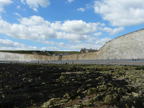
Dry valley cliff section at Birling Gap exposing Pleistocene valley fill deposits overlying deeply weathered chalk. The wavecut chalk platform is extensive and accessible here.
Photograph taken: 09/08/2011
Grid ref TV55439580
Direction NNW
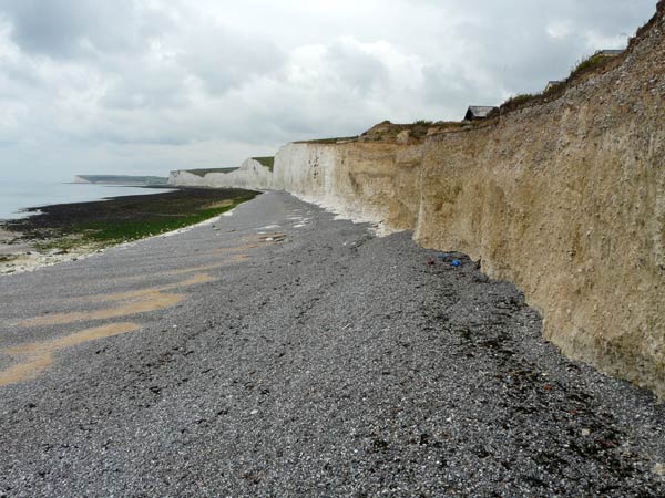
Dry valley cliff section to west of steps at Birling Gap showing Pleistocene valley fill deposits overlying deeply weathered chalk extending down to beach level.
Photograph taken: 21/07/2011
Grid ref TV55389599
Direction WNW
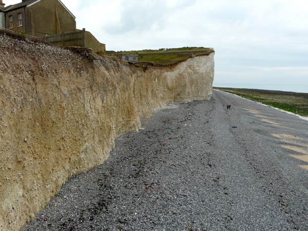
Dry valley cliff section to east of steps at Birling Gap showing Pleistocene valley fill deposits overlying deeply weathered chalk extending down to beach level.
Photograph taken: 21/07/2011
Grid ref TV55389599
Direction SE
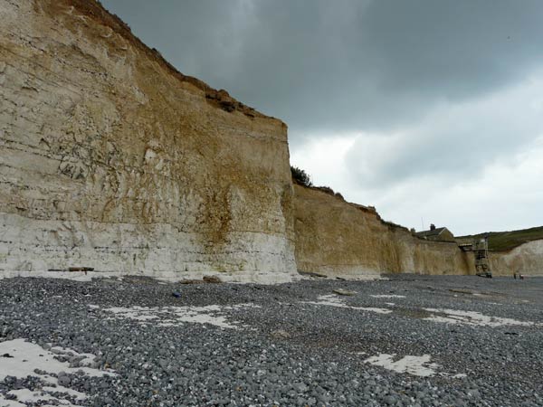
Sharply defined western edge of dry valley deposits. Pleistocene flint gravels and fine chalky wash are underlain by chalk showing lateral transition from fresh chalk with regular flint layers to deeply weathered chalk with distorted and disrupted flint layers.
About 20 m high.
Photograph taken: 21/07/2011
Grid ref TV55309603
Direction SE
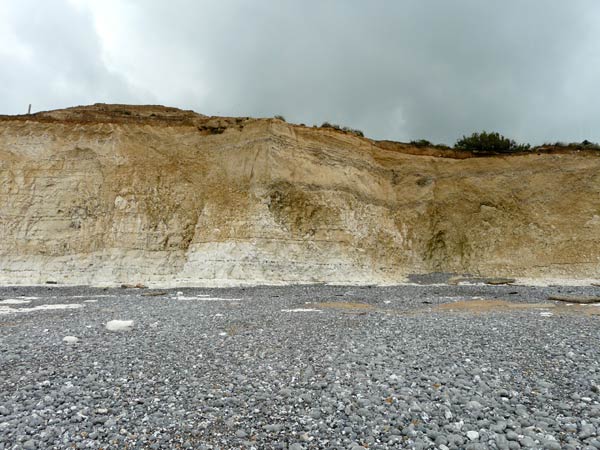
Sharply defined western edge of dry valley deposits. Pleistocene flint gravels and fine chalky wash are underlain by chalk showing lateral transition from fresh chalk with regular flint layers to deeply weathered chalk with distorted and disrupted flint layers.
About 20 m high.
Photograph taken: 21/07/2011
Grid ref TV55289606
Direction NE
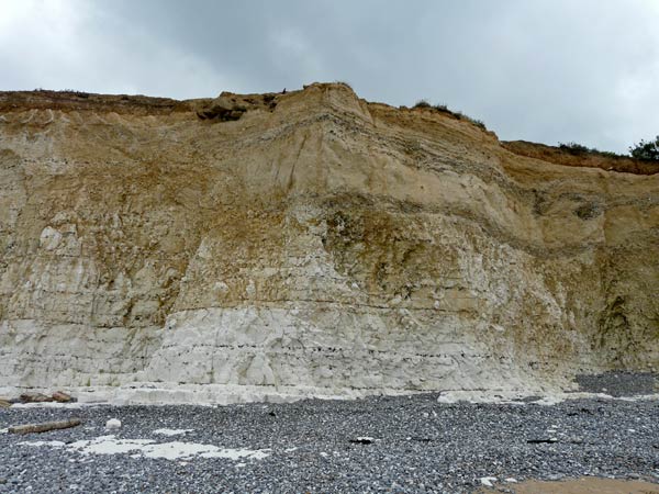
Close-up of western edge of dry valley. Pleistocene flint gravels and fine chalky wash are underlain by chalk showing lateral transition from fresh chalk with regular flint layers to deeply weathered chalk with distorted and disrupted flint bands.
About 20 m high.
Photograph taken: 21/07/2011
Grid ref TV55319604
Direction NE
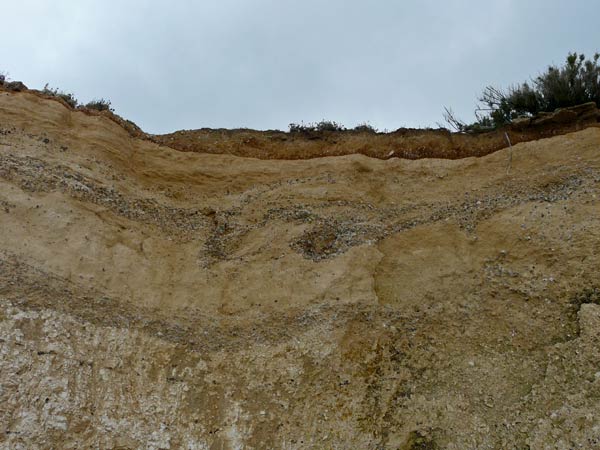
Detail of Pleistocene deposits near western edge of dry valley shown in photo 6. Thin brownish loessic deposits at top overlie head deposits comprising pale chalky wash with interbedded flint gravels. The flint gravels at centre show marked involutions. At the bottom is weathered chalk with disturbed flint layers.
Photograph taken: 21/07/2011
Grid ref TV55329604
Direction NE
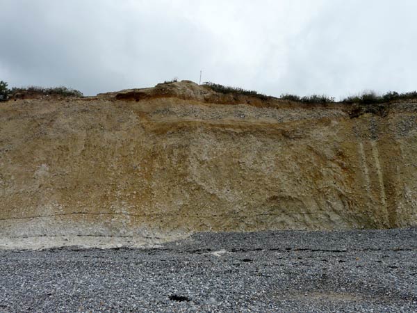
Pleistocene flint gravels and flinty coombe rock with contorted lower section overlying deeply weathered rubbly chalk. Base of flint bands mostly disrupted except for those near the base of the cliff.
About 15 m high.
Photograph taken: 21/07/2011
Grid ref TV55339602
Direction NE
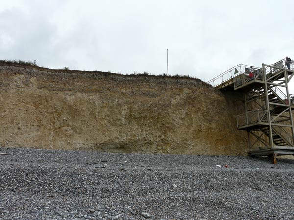
Central part of dry valley west of the steps showing Pleistocene flint gravels and flinty coombe rock with contorted lower section overlying deeply weathered rubbly chalk. Flint bands in the chalk are completely disrupted.
Photograph taken: 21/07/2011
Grid ref TV55369599
Direction ENE
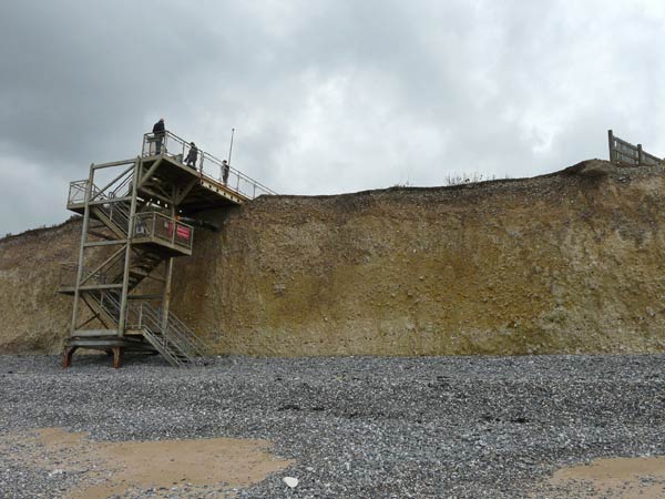
Pleistocene flint gravels and flinty coombe rock to the east of the steps overlying deeply weathered rubbly chalk. Flint layers in the chalk are completely disrupted.
About 10 m high.
Photograph taken: 21/07/2011
Grid ref TV55389596
Direction NNE
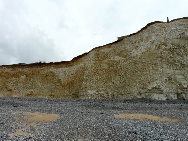
Eastern edge of dry valley. Pleistocene flint gravels and flinty coombe rock at left with thin overlying loessic layer extending beyond. Underlain by chalk showing lateral transition from weathered chalk with distorted and disrupted flint bands to fresh chalk with regular flint bands.
Photograph taken: 21/07/2011
Grid ref TV55429591
Direction NE