
Coastal section: Cow Gap
Sussex RIGS number: TV59/10e
Forms part of the Seaford to Beachy Head SSSI designated for its geological and biodiversity value (Site Code 1000182)
The LGS site is located in Unit 1 of the SSSI.
Forms part of the Beachy Head to Seaford Head Geological Conservation Review (GCR) Site
Block: Coastal Geomorphology of England (Site Code 1850)
Designated as Cow Gap Geological Conservation Review (GCR) Site
Block: Quaternary of South-East England (Site Code 792)
Cow Gap LGS is within the South Downs National Park
Grid Reference: TV597957
Owner:
Eastbourne Borough Council
Site access:
The foreshore between Beachy Head and Eastbourne is accessible from the steps at Cow Gap.
Cow Gap can be reached by about 1.5 km of public footpaths or open access land from Beachy Head Countryside Centre where there is a large pay and display car park.
Cow Gap can also be reached from Eastbourne along the cliff top footpath or along the foreshore at low tide, a distance of about 1.5 km.
Care should be taken regarding potential cliff falls, landslides and tide conditions.
Summary Description:
10/08/2011 and 22/09/2011
(from East Sussex RIGS Survey 2011)
Interest Feature(s)
Bedrock:
Low undefended cliffs and foreshore extending 1.4 km NNE from Head Ledge. The low cliffs (10 to 20 m) expose Chalk and Upper Greensand at the toe of rotational slips above the Gault Clay. Upper Greensand forms reefs along the coast the most prominent of which is Head Ledge. The Gault Clay is only intermittently exposed.
Stratigraphy: Gault Formation and Upper Greensand Formation, Lower Cretaceous (Albian) in age. West Melbury Marly Chalk Formation, White Chalk Subgroup, Upper Cretaceous (Cenomanian) in age.
Sedimentology: Gault Formation: clays deposited in a shelfal marine environment. Upper Greensand: basal green glauconitic sand overlain by fine-grained, calcareous sandstones including bands of calcareous doggers. Deposited in a shallow marine environment. West Melbury Marly Chalk: Glauconitic Marl member at base overlain by alternating chalk limestone and marl beds. Deposited in a relatively deep marine environment.
Sedimentary structures: Upper Greensand is strongly bioturbated. Rhythmic bedding can be seen in the West Melbury Marly Chalk, and both the contacts (Gault/Upper Greensand, Upper Greensand/Glauconitic Marl) are burrowed.
Structural Geology: dip is to the west.
Palaeontology: Fossils in the Upper Greensand are generally rare although, ammonites, nautiloids, bivalves and echinoids have been found. Ammonites have been found in the Gault, The burrows in contact with the Glauconitic marl belong to Thalassinoides sp. Sponges are commonly found in the Glauconitic Marl and the phosphatic nodules are fossiliferous. The Chalk has abundant Inoceramus fossils and other fossils such as bivalves, fish and ammonites.
Superficial deposits:
Pleistocene solifluction deposits are exposed at the head of the landslips and are associated with scarp-face embayments.
Stratigraphy: Pleistocene, probably Devensian or Loch Lomond Stadial in age, and Holocene.
Sedimentology: coombe rock, above which are bedded chalk muds and pale grey fossil soils and capping the whole section a complex sequence of chalk hillwashes of post glacial period.
Geomorphology:
The landslips on this part of the coast are famous, and are believed to have occurred in post-Pleistocene times. The Chalk and Upper Greensand have formed rotational slips over the Gault. The beds dip in a westerly direction at this point, and there is an inland cliff parallel to the coast formed at the head of the rotational slips. A unique series of amphitheatre-like embayments are cut into the face of the Chalk escarpment which may have been formed under periglacial conditions. The deposits laid down on the floor of the most southerly embayment can be seen in the cliff top at Cow Gap.
Site map - Aerial photography 2005 - Survey visits 10/08/2011, 22/09/2011
RIGS Designation Criteria:
Scientific Details and Site Description
This coastal section covers Cow Gap cliff, landslips and wavecut platform.
Stratigraphy: this section of the coast includes the Glauconitic Marl and West Melbury Marly Chalk of the Lower Chalk sequence, the Upper Greensand and the topmost part of the Gault are seen intermittently at the base of the cliffs, all within the Cretaceous period. The Upper Greensand and Chalk have formed rotational landslips above the Gault and have formed Upper Greensand reefs just off the coast.
Sedimentology: the Gault is seen as a mudstone and its contact with the overlying Upper Greensand is very burrowed. The Upper Greensand is a dark green glauconitic sand, passing upwards into a slightly micaceous calcareous sandstone with several bands of calcareous doggers. These beds are exposed at the base of the cliffs and on the beach forming the prominent reef known as Head Ledge. The Glauconitic Marl, although difficult to find is intensely burrowed, the Marl has phosphatic nodules and concretions.
Sedimentary structures: rhythmic bedding can be seen in the Lower Chalk, and both the contacts (Gault/Upper Greensand, Upper Greensand/Glauconitic Marl) are burrowed. Doggers are present in some beds in the Upper Greensand.
Palaeontology: fossils in the Upper Greensand are generally rare although, ammonites, Nautiloids, bivalves mand echinoids have been found in the Upper Greensand. Ammonites have been found in the Gault, The burrows in contact with the Glauconitic marl belong to Thalassinoides sp., there are also sponges commonly found in the Glauconitic Marl and the phosphatic nodules are fossiliferous. The Chalk has abundant Inoceramus fossils and other fossils such as bivalves,fish and ammonites.
Geomorphology and Structural Geology: The landslips on this part of the coast are famous, and are believed to have occurred in post-Pleistocene times. The Chalk and Upper Greensand have formed rotational slips over the Gault. The beds dip in a Westerly direction at this point, and there is an inland cliff parallel to the low (40-70ft) sea cliff formed as a result of the rotational slips. A unique series o amphitheatre-like embayments are cut into the face of the Chalk escarpment which may have been formed under periglacial conditions. The deposits laid down on the floor of the most southerly embayment can be seen in the cliff top at Gow Gap. The surface of the Chalk beneath the drift is uneven, and in the depressions lie Combe Rock, above are bedded chalk meltwater muds and pale grey fossil soils and capping the whole section a complex sequence of brown or reddish humic chalk hillwashes of post glacial period. At Cow Gap the ground has been greatly disturbed by landslipping attributed to glacial or fluvioglacial erosion, but molluscan work by Kerney on the molluscan faunas and fossil soils preserved in the slips indicates this is of postglacial age (Late Devensian) and probably results from marine undercutting of the cliffs.
Educational value: this site is of importance both scientifically and educationally for the presence of the contact zones between: Gault and Upper Greensand; Upper Greensand and Lower Chalk, and for the geomorphological and engineering interest of the rotational landslips. The Upper Greensand/Gault section is unique in Sussex as towards the west there is a facies change and to the east there is no Upper Greensand. The landslips, which preserve a sequence of Late Devensian and Flandrian molluscan faunas and fossil soil, and other features of the area make this a very important site for all students of periglacial, quaternary and chalk landforms. The area is used extensively for recreation and this is the main access the cliffs toward Birling Gap to the West. The cliff top possess a nationally important colony of rare plants. The area is also extremely beautiful with great landscape and amenity value.
SSSI Designation Criteria (citation):
Extracts:
Seaford to Beachy Head is an outstanding site of national importance for its biological and geological features. The diverse range of habitats includes herb-rich chalk grassland, chalk heath (a unique, rare habitat on chalk soils), maritime grassland, foreshore and chalk cliffs, river meanders, and Greensand reef. Together, these habitats support a number of nationally rare, nationally scarce and nationally significant plants, invertebrates and birds.
The cliffs and chalk platform beneath, the Greensand reef, and the chalk escarpment at Cow Gap are identified in the Geological Conservation Review as outstanding for their geological and geomorphological interest.
The site lies at the eastern end of the South Downs which terminate in the chalk cliffs of the Seven Sisters. The majority of the site, therefore, lies on chalk but the River Cuckmere breaches the cliffs to form a broad alluvial valley. There is also a distinct coastal zone which includes all of the geological interest.
Geology
The site is important for earth science interests, particularly for its chalk stratigraphy, periglacial geomorphology and the study of chalk landscape evolution.
Seaford -Beachy Head is a key site for coastal geomorphology, comprising a cliff beach- shore platform system developed on chalk. The site includes the classic coastal cliffs of Beachy Head and the Seven Sisters. In contrast with the cliffs at Foreness Point (Kent) and Kingsdown - Dover (Kent) where structural controls prevail, the plan of the Seaford - Beachy Head coastline is controlled primarily by wave energy; with the dominant and prevailing wave energy from the southwest.
The beach is one of six major south west facing beaches in southern England and all of the others differ significantly in geological characteristics. In addition the beach is the most rapidly and consistently fed by flint from cliff falls.
Cow Gap is an important site for another aspect of periglacial geomorphology and the study of chalk landscape evolution. It is one of a set of otherwise unique amphitheatre-like embayments cut into the face of the Chalk escarpment between Eastbourne and Beachy Head. These features are thought to have been produced by bodies of snow or ice under very cold climatic conditions, which developed at some stage before the late Devensian. Cow Gap, which is truncated by the cliff line, provides the best known exposure of the deposits related to a scarp face embayment The infill deposits are the product of solifluction and sediments deposited by meltwater, and preserve an important sequence of Devensian lateglacial and Flandrian molluscan faunas and a late glacial fossil soil.
GCR Site Account:
Beachy Head to Seaford Head
Block: Coastal Geomorphology of England (Site Code 1850)
Introduction
The Chalk of the South Downs reaches the sea between Brighton and Eastbourne in a series of cliffs that become generally higher towards the east and culminate in the 150 m-high cliffs of Beachy Head. This site comprises a cliff-beach-platform system developed on the Chalk, includes the classic world-renowned cliffs of Beachy Head and the Seven Sisters, and cuts across the mouth of the Cuckmere Valley. The cliffs reach a maximum height of 156 m at Beachy Head (TV588956) and vary between 14 m and 79 m in height along the Seven Sisters. Retreat of the cliffs has been estimated at 0.42 m a-1, reaching a maximum of 0.91 m a-1 at Birling Gap (May, 1971a). A narrow fringing beach of chalk and flint rests upon the cliff-platform junction, except where major falls, especially at Beachy Head, extend below low-tide level. Debris ramparts from cliff-falls are common at Beachy Head. The coastline plan is controlled primarily by dominant and prevailing wave energy from the south-west, with Seaford Head and Beachy Head acting as more resistant points between which a predominantly wave-energy controlled shoreline has developed. Structural variations seem to have had little effect upon the overall coastal plan, the cliff materials being sufficiently rapidly eroded to ensure control by wave action. However, in detail the cliffs are controlled by a rectilinear jointing pattern. The beach is one of six major SW-facing beaches in southern England, all of which differ significantly in their geological characteristics. Most of the site faces south-west and is exposed to Atlantic waves. The fetch from the south-west is similar to that which affects all the major beaches in the English Channel. The cliff and beach of Seven Sisters in particular is unusual in having a very strong similarity in its alignment to such beaches as Chesil Beach and Dungeness. Of the beaches, Seven Sisters beach is the most rapidly and consistently fed by flint from cliff-falls. The most directly comparable cliffs also comprise Upper Chalk along the Normandy coast, but they lack the same aspect and degree of exposure.
Description (extract)
The easternmost part of the site is aligned south-west-north-east and has a cliff height of 24 m. The upper part of the cliff is formed by a staircase of narrow slipped blocks. At the foot of the cliffs, both the Upper Greensand and the Gault Clay crop out, failures in the latter giving rise to the upper cliff features. The platform is distinguished by several repeated outcrops of these rocks, which appear to be related to mass-movements that have penetrated below sea level. At the northern end of the site several springs flow from the top of the Plenus Marl and may affect the erosion of the cliffs. The beach is formed of flint and chalk rubble, and extends northwards towards Eastbourne where it is dominated by flint, the Chalk typically being worn down over a distance of about 1 km.
Cow Gap LGS site represents part of sub-unit 1 of the GCR:
The Chalk cliffs and Greensand and Gault Clay platforms below Cow Gap and Whitebread Hole (TV 600 968 to TV 595 955).
The full site account is on the JNCC website.
Published in the Geological Conservation Review
Volume 28: Coastal geomorphology of Great Britain (2003)
Chapter 4: Soft-rock cliffs
Cow Gap GCR
Block: Quaternary of South-east England (Site Code 792)
Site account not available
East Sussex Local Geological Sites - Coastal Section Cow Gap
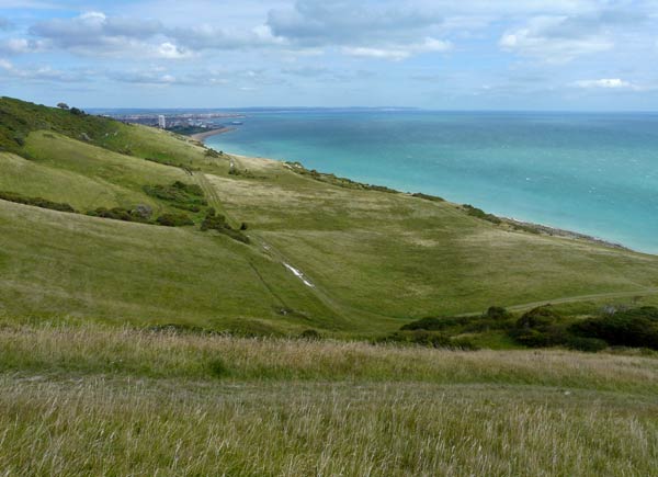
Series of small embayments on the left in the chalk escarpment above Cow Gap. The top of the cliffs at right marks the head of a series of landslips, exposing the superficial deposits associated with the embayments.
Photograph taken: 10/08/2011
Grid ref TV60199570
Direction NE
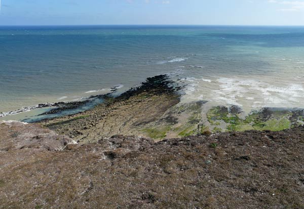
Upper Greensand forms the Head Ledge reef.
Photograph taken: 10/08/2011
Grid ref TV60369561
Direction south
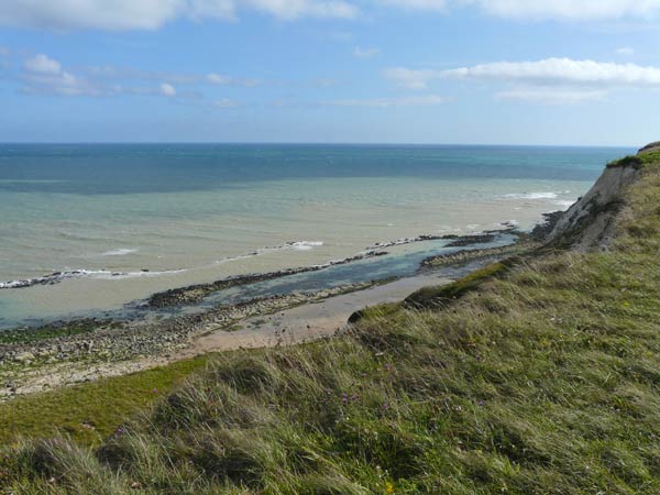
Edge of scarp above Cow Gap with landslipped area below. Upper Greensand wavecut platform and reefs form the toes of a series of ancient landslips over the underlying Gault Clay. Ridges of Upper Greensand protect shallow lagoons underlain by Gault Clay.
Photograph taken: 10/08/2011
Grid ref TV60489572
Direction SE
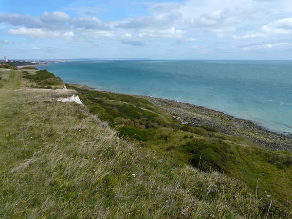
Edge of scarp above Cow Gap with landslipped area below. Upper Greensand wavecut platform and reefs form the toe of the rotational slides over the underlying Gault Clay. The scarp face exposes chalk and locally also exposes Pleistocene solifluction deposits overlying chalk.
Photograph taken: 10/08/2011
Grid ref TV60499574
Direction NE
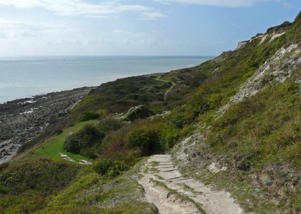
Profile of landslip area above Cow Gap, locally exposing chalk overlain by Pleistocene solifluction deposits at head of scarp. Upper Greensand wavecut platform and reefs form toe of rotational slides over the underlying Gault Clay.
Photograph taken: 22/09/2011
Grid ref TV60729604
Direction SSW
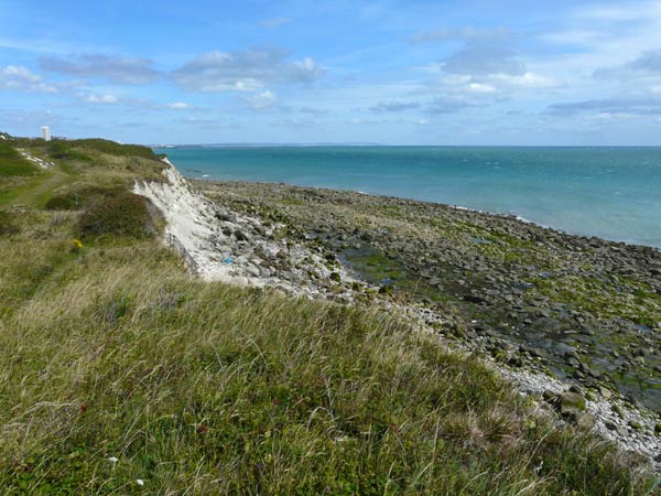
Low chalk cliffs at foot of landslide area at Cow Gap with Upper Greensand wavecut platform exposed.
Photograph taken: 10/08/2011
Grid ref TV60619576
Direction NE
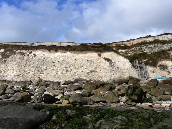
Cow Gap steps with low cliffs of West Melbury Marly Chalk and Upper Greensand boulders on beach. Top of cliff and the scarp at head of landslide area above expose Pleistocene solifluction deposits overlying chalk.
Photograph taken: 22/09/2011
Grid ref TV60689578
Direction WNW
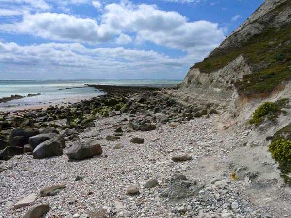
Cliffs to south of Cow Gap exposing the transition from Upper Greensand through Glauconitic Marl to West Melbury Marly Chalk. Dip to right (west) at toe of rotational slides. Upper Greensand forms a minor reef at left and Head Ledge, an extension of the wavecut platform at centre.
Photograph taken: 10/08/2011
Grid ref TV59559566
Direction SSW
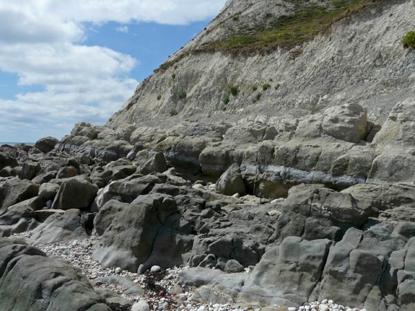
Foot of cliffs south of Cow Gap showing closer view of transition from Upper Greensand to Glauconitic Marl (1 m pole for scale) and West Melbury Marly Chalk. Dip to right (west) at toe of rotational slide.
Photograph taken: 10/08/2011
Grid ref TV60549563
Direction SSW
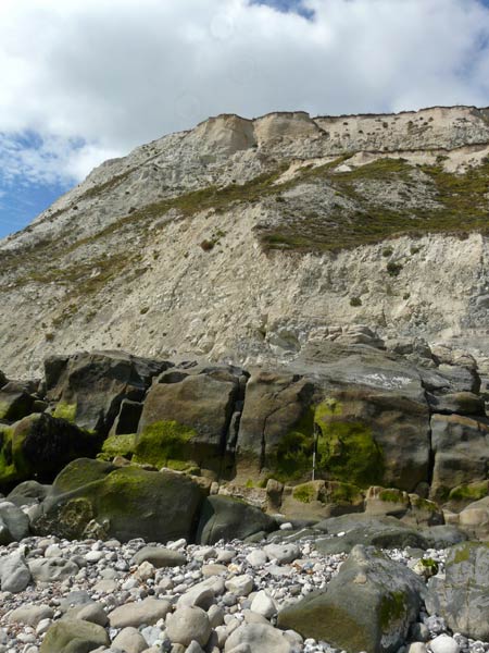
Cliffs south of Cow Gap showing sequence from Upper Greensand (1 m pole for scale) to Glauconitic Marl, West Melbury Marly Chalk and Zig Zag Chalk. Dip related to toe of rotational slide.
Photograph taken: 10/08/2011
Grid ref TV60539561
Direction WNW
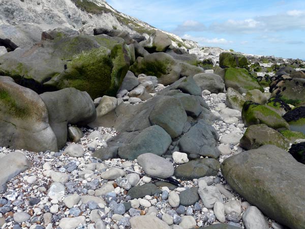
Good example of massive greyish-green Upper Greensand exposed on the beach south of Cow Gap.
1 m pole for scale.
Photograph taken: 10/08/2011
Grid ref TV60529559
Direction NNE
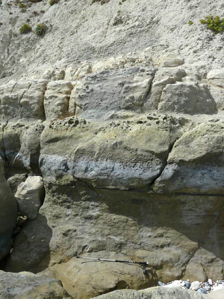
Close-up of uppermost layers of the Upper Greensand overlain by more eroded Glauconitic Marl from which small phosphatic nodules can be seen protruding. This is overlain by West Melbury Marly Chalk.
1 m pole for scale.
Photograph taken: 10/08/2011
Grid ref TV60489558
Direction west
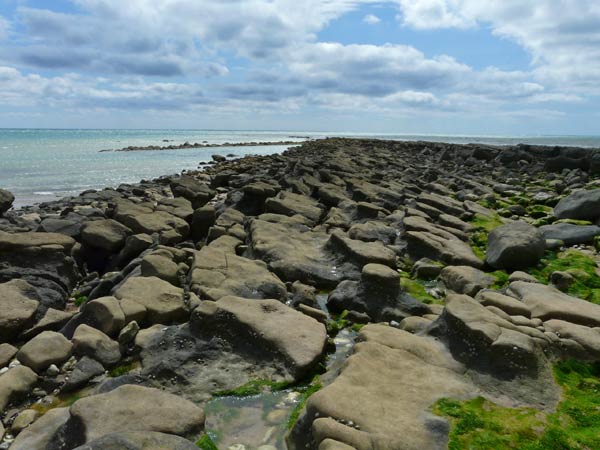
Upper Greensand beds dipping to right (west) along Head Ledge. Minor Upper Greensand reef visible offshore.
Photograph taken: 10/08/2011
Grid ref TV60489556
Direction SSW
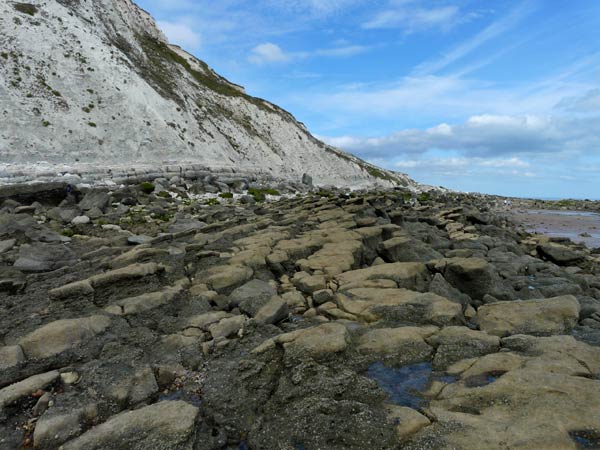
Low cliffs and foreshore south of Cow Gap. Upper Greensand dips to left (west) overlain by Glauconitic Marl along foot of cliff with West Melbury Marly Chalk forming the cliff face.
Photograph taken: 10/08/2011
Grid ref TV60459550
Direction NNE
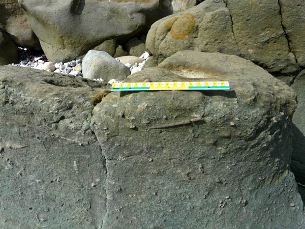
Upper Greensand boulder showing numerous trace fossils (worm tubes?).
30 cm scale.
Photograph taken: 22/09/2011
Grid ref TV60709584
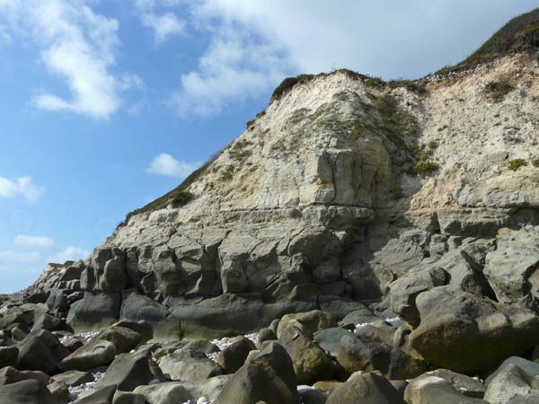
Low cliff north of Cow Gap steps showing well exposed transition from Upper Greensand at base through Glauconitic Marl to West Melbury Marly Chalk.
Photograph taken: 22/09/2011Grid ref TV60729587
Direction SW
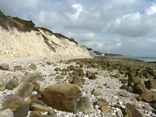
Low cliffs of West Melbury Marly Chalk and the Upper Greensand wavecut platform north of Cow Gap steps.
Photograph taken: 22/09/2011
Grid ref TV60749594
Direction NNE
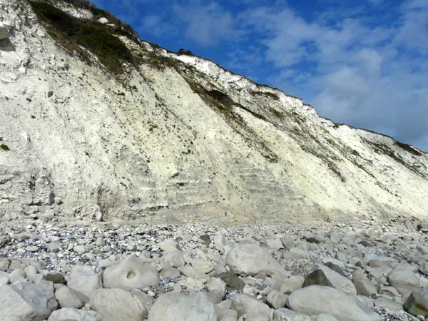
Cliffs up to 40 m high near the northern end of the site exposing West Melbury Marly Chalk in the lower cliff . Debris obscures the upper part of the section.
Photograph taken: 22/09/2011
Grid ref TV60829616
Direction NNE